have your say on MATTERS THAT AFFECT bullsbrook
Proposed Use and associated development for a Boar Artificial Insemination Centre - Lot 1780 (No.46) Gaston Road, BULLSBROOK
This application seeks approval to develop a boar artificial insemination centre, which consists of one boar stud shed accommodating a total of 168 pens, 20 quarantine pens, and 4 semen collection pens, laboratory for packaging and quality control, wet room, office amenities/lunch room, storage, toilets, showers, and a dispatch area.
The proposed operations will collect and distribute boar semen to piggeries around Australia. Boars will be housed in the shed.
- There will be one (1) permanent staff member onsite 6 days per week.
- Proposed operational hours are between 4.00am and 8.00am on Mondays, Tuesdays and Fridays when semen will be collected and distributed.
- The proposed development provides employment for:
- one (1) full time employee, 6 days per week;
- one (1) part time employee, 1 day per week; and
- three (3) part time employees (collection days), 3 day per week.
- The boar shed will accommodate a maximum of 188 boars at any one time.
- The total building area of the proposed development is 2,012m2.
- The development is within the setbacks prescribed for the General Rural zone under POL-TP-126.
- Vehicle access to and from the site is via Morley Road. This crossover is proposed to be constructed to a rural standard, largely of compacted gravel and crushed dust.
- An average of 34.3 vehicle movements is expected to and from the site on a weekly basis.
Bullsbrook Freight and Industrial District Structure Plan update
Consultants GHD prepared an initial draft concept plan which was discussed at the community workshop in late 2018. We also advised community members that a draft structure plan would be released for public comment earlier in the year.
Following this workshop a draft Structure Plan and technical studies (including a district water management strategy, environment study, strategic transport strategy, industrial land demand and market analysis, bushfire hazard assessment and infrastructure servicing report) was prepared and circulated to the relevant agencies for their comment prior to seeking endorsement for public release. As a result of this preliminary stakeholder feedback a number of critical issues was identified which has delayed the delivery of the project. These issues are primarily in relation to the amount of information required / expected by government agencies responsible for reviewing and approving these technical studies. This includes the need to undertake more detailed road planning and modelling and further works required to inform the Water Management Strategy.
At this stage it is anticipated to take an additional 6 months to undertake this works (at additional cost) required to the finalise the technical studies. As a result the release of the draft structure plan is now anticipated to be released for public comment later in the year, approximately October 2019. Once I have confirmation of the works required, the project timeframes will be updated on the website so that the public are aware of the delay.
Proposed Scheme Amendment No. 169 - To insert Development Contribution Plan provisions into Schedule 13 for Development Contribution Area 4 - South Bullsbrook Industrial Precinct (DCA 4)Prior to Council giving further consideration, comments are being sought on the above scheme amendment and the November 2018 draft South Bullsbrook Industrial Development Contribution Plan (DCP).
This proposal is to establish statutory provisions for the levying of contributions towards road and drainage infrastructure that the South Bullsbrook Industrial Area will need and/or benefit from its timely provision. The area that will be liable to make a contribution is identified as 'Developable Land' on the DCP's Infrastructure Demand Map.
The Amendment 169 document details the proposed changes to the scheme and lists the infrastructure to be funded. The Development Contribution Plan details the cost implications and estimates the cost contribution rate. The supporting info is key background documents that informed, directed or elaborates on the content of the Scheme Amendment and DCP.
Please view the documents below for further information:
LPS17-169 Zoning Map(PDF, 3MB)Opens in new window
LPS17-169 Amendment Document(PDF, 1MB)Opens in new window
LPS17-169 DCP for DCA 4 - South Bullsbrook Industrial - Nov 2018(PDF, 9MB)Opens in new window
LPS17-169 supporting info - Bullsbrook DCP -Traffic Assessment Cardno - October 2014(PDF, 5MB)Opens in new window
LPS17-169 supporting info - land valuation report DCA 4 v143-18 - FINAL report as at 19.06.18(PDF, 2MB)Opens in new window
LPS17-169 supporting info - Transcore report of June 2018(PDF, 3MB)Opens in new window
LPS17-169 supporting info - T&T DCP Cost Review Report(PDF, 3MB)Opens in new window
Closing date for submissions: May 1, 2019. Reference No. LPS17-169. Responsible Officer: Mariska van der Linde.
Proposed Community Purpose Facility (Shalom House) - including incidental operational and administrative functions, religious, social and recreational activities, cafe, part demolition works, buildings and works to construct new buildings/structures, car parking areas, landscaping works and associated civil works - Lot 7 (No.1973) Great Northern Highway, BULLSBROOK
The City has received the abovementioned proposal for consideration.
The proposal consists of the following:
Stage 1
DA002-19-Development-Plan(PDF, 10MB)Opens in new window
DA002-19-Planning-Report(PDF, 3MB)Opens in new window
DA002-19-Transport-Statement(PDF, 1MB)Opens in new window
Closing date for submissions: February 27, 2019. Reference No: DA002-19 Responsible Officer: Rebecca Lodge
The City has received the abovementioned proposal for consideration.
The proposal consists of the following:
Stage 1
- Use of an existing 432m2 shed for the storage of vehicles, plant and equipment associated with Shalom Works and Shalom Labour Hire;
- Construction of a 384m2 shed in colorbond eucalypt green for the storage of vehicles, plant and equipment associated with Shalom Works and Shalom Labour Hire as well as building materials associated with the future construction works planned for the property;
- Installation of six (6) Transportable buildings, each 96m2, to be used temporarily to house the administrative operations and act as the construction supervision offices while the new buildings are constructed. They will be removed once main buildings are completed.
- Installation of a limestone hardstand area of approximately 5,000m2 to be used for parking of Shalom House and Shalom Works vehicles and staff vehicles;
- Development of a 40m x 24m colorbond clad building with a wall height of 4.6m and peak height of 6.826. It will include a 480m2 mezzanine floor. It is shown to be used as a Workshop;
- Amended site access and egress arrangements to Great Northern Highway, with closure of the existing access and construction of a 62 bay parking area;
- Installation of a 1.2m high post and wire fence outside the vegetation line associated with the Ellen Brook;
- Construction of a 1.8m high steel mesh fence along Lot 7’s southern boundary and planting of a vegetation screen;
- Construction of a two storey Community Centre with a total floor area of 2,053m2and maximum height of 8.75m comprising of
- 1,522m2 floor space on the ground level containing an auditorium with seating for 503 persons, quiet viewing room with seating for 20 persons, an entry foyer, a kitchen, a café, a children’s crèche, utilities and toilet facilities
- 531m2 of floor space on the first floor of which 370m2 will be used for administrative operations, and the remainder a mezzanine level viewing area over the auditorium with capacity to set 98 persons (total auditorium capacity 621 persons)
- The primary use of the auditorium is for Shalom Church services on weekends and other Church and WASG related activities at other time such as meetings, seminars, presentations, family and group events and other community outreach programs.
- Conversion of the 40m x 24m colorbond clad building for multi-purpose space for a range of indoor recreation activities
- Further extension of the carparking area with the addition of 138 car parking bays (total of 200 car parking bays)
- Landscaping of the parking area, frontage of Lot 7 and surrounds of the new building
- The auditorium is proposed to be used between 9:00am and 10:00pm Monday – Thursday, between 7:00am and 11:00pm Friday, between 8:00am and 11:00pm Saturday and between 8:00am and 10:00pm Sunday.
- The Administration building is proposed to be used between 7:00am and 7:00pm Monday to Friday, between 7:00am and 2:00pm Saturday and closed on Sunday
- The Café is proposed to be used between 6:30am and 3:00pm Monday to Sunday
- The Indoor Recreation Centre is proposed to be used between 9:00am to 10:00pm Monday to Friday and between 8:00am to 5:00pm on the weekend
- The applicant submits that the proposed activities are to occur intermittently between the hours listed in the following table, rather than consistently.
- The applicant submits that during the course of construction in each of the proposed stages, and upon the completion of the development, the peak number of 60 WASG staff would be expected on site during weekday working hours.
DA002-19-Development-Plan(PDF, 10MB)Opens in new window
DA002-19-Planning-Report(PDF, 3MB)Opens in new window
DA002-19-Transport-Statement(PDF, 1MB)Opens in new window
Closing date for submissions: February 27, 2019. Reference No: DA002-19 Responsible Officer: Rebecca Lodge
West Bullsbrook Freight and Industrial Structure Plan
Report from the community information session and maps available here (8mb file)
Report from the community information session and maps available here (8mb file)
Proposed Scheme Amendment No.158 - To rezone from 'General Rural' to 'Residential Development' portion of Lot 1165 Hurd Road, Lots 900, 901 & 1396 Chittering Road and Lot 1354 Great Northern Highway, Bullsbrook The City invites comment on the above proposed Amendment to its Local Planning Scheme No. 17. Amendment No. 158 proposes to change the zoning from 'General Rural' to 'Residential Development' in accordance with the State Government's decision to rezone the land to 'Urban' under the Metropolitan Region Scheme. Please view the attached documents for further information.
LPS17-158 Location Plan(PDF, 1MB)Opens in new window
LPS17-158 Initiated Amendment Document(PDF, 5MB)Opens in new window
Closing date for submissions: April 9, 2018. Reference No. LPS17-158. Responsible Officer: Sherriden Turner
LPS17-158 Location Plan(PDF, 1MB)Opens in new window
LPS17-158 Initiated Amendment Document(PDF, 5MB)Opens in new window
Closing date for submissions: April 9, 2018. Reference No. LPS17-158. Responsible Officer: Sherriden Turner
Proposed Bullsbrook Central Structure Plan - Various lots in Great Northern Highway, Chittering Road, Hurd Road & Taylor Road, Bullsbrook
The City has received an application for a Local Structure Plan that proposes to guide the urban development of the "Bullsbrook Central" area, which is identified as approximately 267 hectares and located to the east of Chittering Road and Great Northern Highway. The key aspects of development by the Local Structure Plan are as follows:
SWAN-SP-2017-5-Structure-Plan-Report-Part-1-and-2.pdf(PDF, 10MB)Opens in new window
SWAN-SP-2017-5-Appendix-1_Bushfire-Management-Plan-reduced.pdf(PDF, 3MB)Opens in new window
SWAN-SP-2017-5-Appendix-2_Transportation-Noise-Assessment.pdf(PDF, 2MB)Opens in new window
SWAN-SP-2017-5-Appendix-4_Environmental-Summary-Report.pdf(PDF, 30MB)Opens in new window
SWAN-SP-2017-5-Appendix-5_Local-Water-Management-Strategy-Part-1-of-2.pdf(PDF, 67MB)Opens in new window
SWAN-SP-2017-5-Appendix-5_Local-Water-Management-Strategy-Part-2-of-2.pdf(PDF, 35MB)Opens in new window
SWAN-SP-2017-5-Appendix-6_Aboriginal-Heritage-Desktop-Assessment.pdf(PDF, 811KB)Opens in new window
SWAN-SP-2017-5-Appendix-7_Transport-Impact-Assessment.pdf(PDF, 3MB)Opens in new window
SWAN-SP-2017-5-Appendix-8_District-Activity-Centre-Precedent-Imagery.pdf(PDF, 3MB)Opens in new window
SWAN-SP-2017-5-Appendix-9_Retail-Market-Demand-Review.pdf(PDF, 855KB)Opens in new window
SWAN-SP-2017-5-Appendix-10_Landscape-and-Irrigation-Strategy.pdf(PDF, 5MB)Opens in new window
SWAN-SP-2017-5-Appendix-11_Engineering-Servicing-Report.pdf(PDF, 7MB)Opens in new window
Closing date for submissions: January 3, 2018. Reference No: SWAN-SP/2017/5. Responsible Officer: Asha Logan.
The City has received an application for a Local Structure Plan that proposes to guide the urban development of the "Bullsbrook Central" area, which is identified as approximately 267 hectares and located to the east of Chittering Road and Great Northern Highway. The key aspects of development by the Local Structure Plan are as follows:
- approximately 2,809 new residential dwellings averaging in lot size from 150m2 in select locations to 2,000m2;
- an increased population of approximately 7,865 people;
- one district level park (6.3ha) and 19 new neighbourhood and local parks, including some along the Ki-it Monger Brook and existing wetlands;
- a public primary school;
- a new 'General Commercial' zone of up to 25,000m2 retail floor space;
- a 'Private Clubs & Institutions' zone of 2,100m2 area;
- re-alignment and upgrade of Chittering Road through the site as a key transit corridor; and
- upgrade of Maroubra Avenue to connect to Great Northern Highway.
SWAN-SP-2017-5-Structure-Plan-Report-Part-1-and-2.pdf(PDF, 10MB)Opens in new window
SWAN-SP-2017-5-Appendix-1_Bushfire-Management-Plan-reduced.pdf(PDF, 3MB)Opens in new window
SWAN-SP-2017-5-Appendix-2_Transportation-Noise-Assessment.pdf(PDF, 2MB)Opens in new window
SWAN-SP-2017-5-Appendix-4_Environmental-Summary-Report.pdf(PDF, 30MB)Opens in new window
SWAN-SP-2017-5-Appendix-5_Local-Water-Management-Strategy-Part-1-of-2.pdf(PDF, 67MB)Opens in new window
SWAN-SP-2017-5-Appendix-5_Local-Water-Management-Strategy-Part-2-of-2.pdf(PDF, 35MB)Opens in new window
SWAN-SP-2017-5-Appendix-6_Aboriginal-Heritage-Desktop-Assessment.pdf(PDF, 811KB)Opens in new window
SWAN-SP-2017-5-Appendix-7_Transport-Impact-Assessment.pdf(PDF, 3MB)Opens in new window
SWAN-SP-2017-5-Appendix-8_District-Activity-Centre-Precedent-Imagery.pdf(PDF, 3MB)Opens in new window
SWAN-SP-2017-5-Appendix-9_Retail-Market-Demand-Review.pdf(PDF, 855KB)Opens in new window
SWAN-SP-2017-5-Appendix-10_Landscape-and-Irrigation-Strategy.pdf(PDF, 5MB)Opens in new window
SWAN-SP-2017-5-Appendix-11_Engineering-Servicing-Report.pdf(PDF, 7MB)Opens in new window
Closing date for submissions: January 3, 2018. Reference No: SWAN-SP/2017/5. Responsible Officer: Asha Logan.
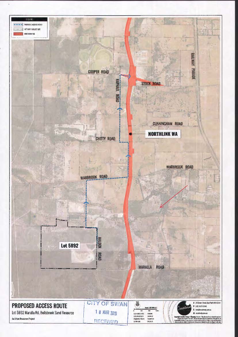
Proposed Use of the land for Industry-Extractive and associated development including rehabilitation and construction of an access track for transportation - Lots 10 & 104 (No. 5 & 43) Sawpit Road, BULLSBROOK.
The City has received the abovementioned proposal for consideration. The proposal seeks planning approval and a subsequent extractive industry licence from the City of Swan for the extraction of sand to supply the future Northlink construction project.
Details of the proposal are as follows.
DA447-17-Plans(PDF, 389KB)Opens in new window
DA447-17-Report(PDF, 6MB)Opens in new window
DA447-17-Dust-Management-Plan(PDF, 5MB)Opens in new window
DA447-17-Noise-Management-Plan(PDF, 9MB)Opens in new window
DA447-17-Water-Management-Plan(PDF, 11MB)Opens in new window
Closing date for submissions: September 6, 2017. Reference No: DA447-17. Responsible Officer: Craig Zanotti
The City has received the abovementioned proposal for consideration. The proposal seeks planning approval and a subsequent extractive industry licence from the City of Swan for the extraction of sand to supply the future Northlink construction project.
Details of the proposal are as follows.
- Days and hours of operation:Sand extraction Monday to Friday 7am to 5pm
Disposal of sand Monday to Friday 10am to 5pm
Saturday 10am to 3pm
- Estimated time of completion for sand extraction: 12 months
- Proposed excavation and volume of sand:600,000 tonnes (across a 14.2ha area) with depth of excavation between 2m and 6m
- Transport of extracted sandThe applicant has indicated that the sand will be transported from the site directly to the Northlink project via private property, utilising a proposed limestone track (approximately 8m wide) which will traverse the southern boundary of Lot 104 (No. 43) Sawpit Road to the western boundary.
- An equipment/machinery compound is proposed in the centre of the property
DA447-17-Plans(PDF, 389KB)Opens in new window
DA447-17-Report(PDF, 6MB)Opens in new window
DA447-17-Dust-Management-Plan(PDF, 5MB)Opens in new window
DA447-17-Noise-Management-Plan(PDF, 9MB)Opens in new window
DA447-17-Water-Management-Plan(PDF, 11MB)Opens in new window
Closing date for submissions: September 6, 2017. Reference No: DA447-17. Responsible Officer: Craig Zanotti
Proposed Site Remediation - 1201 Chittering Road, BULLSBROOK
The City has received the above application for Site Remediation.
The City of Swan previously advertised an application for the rehabilitation of an exhausted clay pit at Lot 12 (No 1201) Chittering Road Bullsbrook on the 9th August 2016. As the application consisted of a crushing and screening component, it was considered an industrial activity and refused under delegated authority on the 13thSeptember 2016. The application is currently under review at the State Administrative Tribunal. As part of this process, the applicants have revised their proposal.
The crushing and screening component was removed from the original application to allow it to be considered as rehabilitation rather than an industrial activity. The amended documentation was received 13th December 2016 and the revised proposal readvertised for public comment on the 19th December 2016.
Through the assessment of the revised proposal, it was confirmed that the use classification was no longer considered an industrial activity and could be considered for approval; however the proposed access to the site via Hoad Street was not feasible.
As such, the application has been amended again to propose access via Lot 11 (No.73) Chittering Road Bullsbrook, a property privately owned by the proponent. Changes of notes include:
Transport Impact Assessment(PDF, 32MB)Opens in new window
(PDF, 32MB)Opens in new windowDrainage Management Plan(PDF, 6MB)Opens in new window
Noise Management Plan(PDF, 15MB)Opens in new window
Dust Management Plan(PDF, 10MB)Opens in new window
Asbestos Management Plan(PDF, 194KB)Opens in new window
Finished Contours(PDF, 157KB)Opens in new window
Closing date for submissions: June 28, 2017. Reference No: SAT-4/2016. Responsible Officer: Rebecca Lodge
This proposal was refused by City of Swan Council at their meeting held on 30 August 2017. The Matter has been referred back to SAT
Proposed Land Rehabilitation - Lot 1 (No.402) Jenkins Road, BULLSBROOK
The City has received the above application for Land Rehabilitation.
The application has previously been advertised on the 11 January 2017, following this referral period the proponent submitted revised information which is now subsequently being re-advertised. The revised information comes from the determination that the proposed access to the Site via Hoad Street was not feasible. Whilst the application remains fundamentally the same the proponent has made the following changes to the application:
Finished Contour Jenkins Pits(PDF, 185KB)Opens in new window
Acoustic Report(PDF, 1MB)Opens in new window
Development Application Report(PDF, 5MB)Opens in new window
Dust and Drainage Management Plans(PDF, 11MB)Opens in new window
Closing date for submissions: June 28, 2017. Reference No: DA861-16. Responsible Officer: Alex Snadden
The City has received the above application for Site Remediation.
The City of Swan previously advertised an application for the rehabilitation of an exhausted clay pit at Lot 12 (No 1201) Chittering Road Bullsbrook on the 9th August 2016. As the application consisted of a crushing and screening component, it was considered an industrial activity and refused under delegated authority on the 13thSeptember 2016. The application is currently under review at the State Administrative Tribunal. As part of this process, the applicants have revised their proposal.
The crushing and screening component was removed from the original application to allow it to be considered as rehabilitation rather than an industrial activity. The amended documentation was received 13th December 2016 and the revised proposal readvertised for public comment on the 19th December 2016.
Through the assessment of the revised proposal, it was confirmed that the use classification was no longer considered an industrial activity and could be considered for approval; however the proposed access to the site via Hoad Street was not feasible.
As such, the application has been amended again to propose access via Lot 11 (No.73) Chittering Road Bullsbrook, a property privately owned by the proponent. Changes of notes include:
- Proposed restriction to the number of trucks/vehicles using Chittering Road during school pick up hours – 2 truck movements in each direction between 3:00pm and 3:30pm weekdays
- No localised road widening to Chittering Road is proposed as the revised access is believed to achieve adequate sightlines. This is currently under technical review.
Transport Impact Assessment(PDF, 32MB)Opens in new window
(PDF, 32MB)Opens in new windowDrainage Management Plan(PDF, 6MB)Opens in new window
Noise Management Plan(PDF, 15MB)Opens in new window
Dust Management Plan(PDF, 10MB)Opens in new window
Asbestos Management Plan(PDF, 194KB)Opens in new window
Finished Contours(PDF, 157KB)Opens in new window
Closing date for submissions: June 28, 2017. Reference No: SAT-4/2016. Responsible Officer: Rebecca Lodge
This proposal was refused by City of Swan Council at their meeting held on 30 August 2017. The Matter has been referred back to SAT
Proposed Land Rehabilitation - Lot 1 (No.402) Jenkins Road, BULLSBROOK
The City has received the above application for Land Rehabilitation.
The application has previously been advertised on the 11 January 2017, following this referral period the proponent submitted revised information which is now subsequently being re-advertised. The revised information comes from the determination that the proposed access to the Site via Hoad Street was not feasible. Whilst the application remains fundamentally the same the proponent has made the following changes to the application:
- A revised access to the subject lot via Lot 11 (No. 73) Chittering Road, Bullsbrook, a property privately owned by the proponent. It should be noted the access applies to both applications being assessed (Jenkins Road and Chittering Road).
- Proposed restriction to the number of trucks/vehicles using Chittering Road during school pick up hours – 2 truck movements in each direction between 3:00 to 3:30pm weekdays.
- No localised road widening to Chittering Road is proposed as the revised access in is believed to achieve adequate sightlines. This is currently under technical review by City staff.
- A revised Acoustic Report was provided to the City of Swan which now indicates a 5m Noise Bund to the pit to the North identified as Area B. This document is currently under technical review by City staff.
Finished Contour Jenkins Pits(PDF, 185KB)Opens in new window
Acoustic Report(PDF, 1MB)Opens in new window
Development Application Report(PDF, 5MB)Opens in new window
Dust and Drainage Management Plans(PDF, 11MB)Opens in new window
Closing date for submissions: June 28, 2017. Reference No: DA861-16. Responsible Officer: Alex Snadden
BULLSBROOK TOWNSITE LAND USE MASTER PLAN 2014
- The Bullsbrook Townsite Land Use Master Plan 2014 has been completed and is available for download here. it is a 5MB file.
- The Bullsbrook Townsite Land Use Master Plan is the strategic planning document to guide the development of the Bullsbrook town centre, and forms the basis for policy formulation and amendments to the Metropolitan Region Scheme and the City of Swan Local Planning Scheme No. 17.